Crossing Garibaldi Park on skis – route description and GPS track download
McBride Traverse is a ski route that spans the length of the vast Garibaldi park. The entire route can clock in somewhere around 100km and ten years ago used to be a major undertaking. However, the young generation of backcountry skiers is pushing the envelope of what’s considered “recreational” and I am seeing parties doing this traverse in substantially less time. Strong navigational skills recommended.
We did this trip some 13 year ago now (wow!). The glaciers have changed (mostly receded, they sit lower than the maps from the 70’s show, perhaps creating headwalls where none existed before), crevasses are in different places than last year… So review our route but make your decisions based on your own field observations.
SEE THE TOPO MAP AND DOWNLOAD GPS TRACK HERE.
Below is an account of our trip from the pen of Dave Scanlon, the trip leader. This post is a bit of a tribute to Dave who graciously took me along on many many mountain adventures when I was a newbie without a clue. About 80% of what I know now about glacier travel, winter camping and team dynamics in the mountains I learned from him. Dave no longer goes on big trips, he is preserving his titanium knees for playing hockey 🙂 but he is one of the best trip leaders I have ever known. Thank you for everything, Dave.
Day 1: Flood Creek FSR to Nivalis Ridge
The car shuttle was solved by us leaving our cars in Whistler and taking a Whistler taxi (read small bus) past Pemberton and then some 40 km down the Lillooet River main line, crossing the river at Tenas Narrows to the west side, and then onwards another 10 km to our logging road access point. I had asked for and was told that we were getting a 4 wheel drive vehicle. I later found out that it had broken down, and they forgot to tell us. It wasn’t what showed up though but our driver, John, put the pedal to the metal and went till the road was blocked by snow. Time to unload. We gave our driver a sizable tip for all his efforts and off he went. Leaving each of us with our own individual thoughts as the quiet reality set in. We are here and about to start on a new adventure.
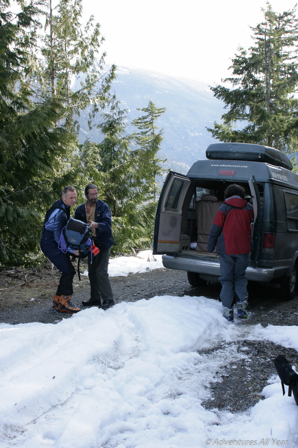
Having been here 4 years previous I knew the way. So off we went skinning up the snow covered logging road to its end. Then up into the open forest to make our first camp in the trees.
Day 2: Nivalis Ridge to Nivalis Glacier
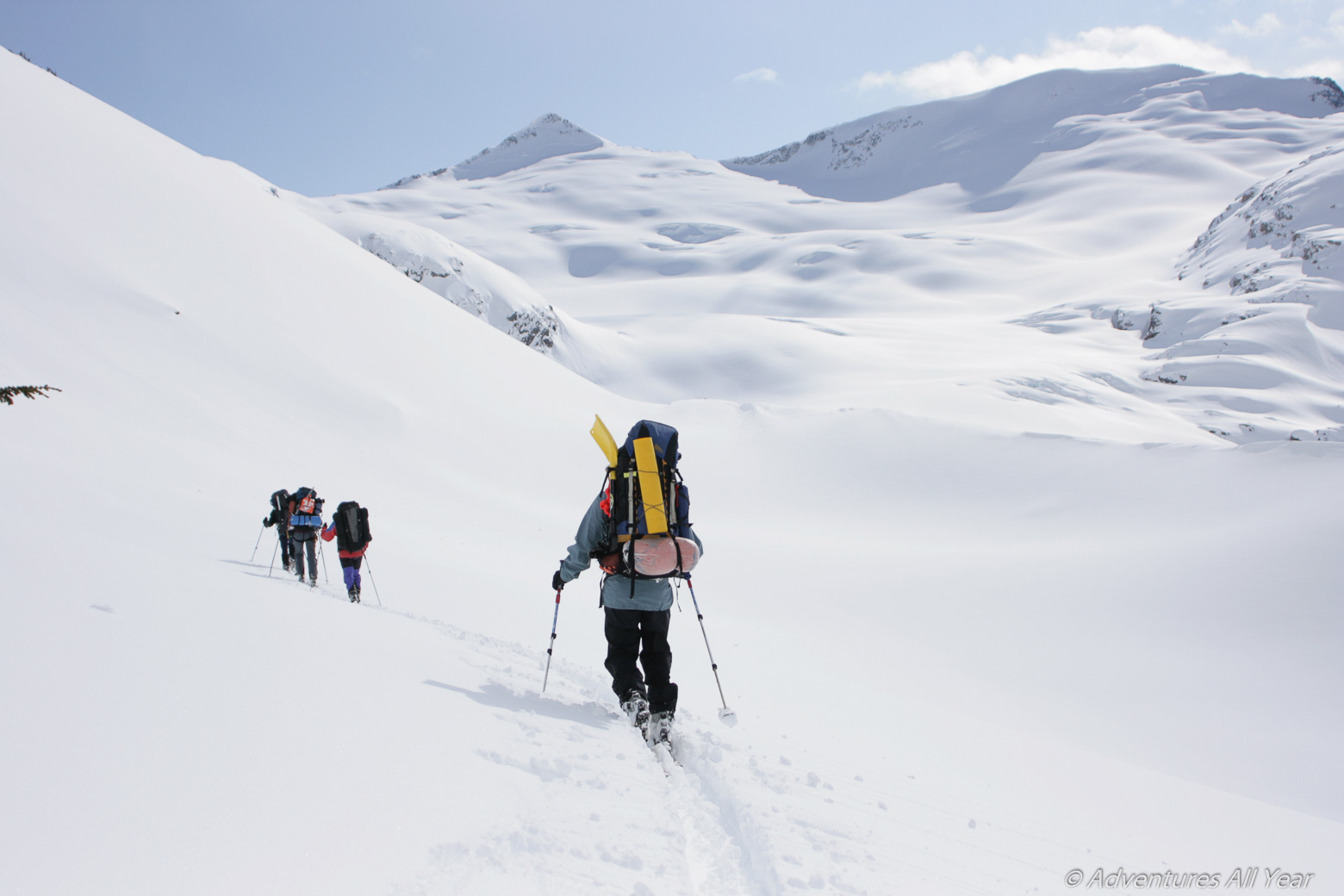
Next day we continued on and up with the forest opening up the higher we went and finally gaining the ridge top. Following the undulating ridge brought Peak 7800 into view, then Talon, then Nivalis Peak. We stopped here for lunch in the brilliant sunshine enjoying the view. Our day ended up with us having a steep descent down onto the Nivalis Glacier and shortly after making camp.

Day 3: Nivalis Glacier to McBride Glacier
Yes or no, try or not to try was our discussion. Pertaining to trying to get around the south ridge of Nivalis to the plateau between it and Sir Richard. The reports indicated that it could be problematic, and, with the 12” or so of new snow, we opted to detour around Nivalis’s north ridge instead, then approaching Sir Richard from the north side on the McBride Glacier. As it turned out we had a most pleasant ski down, and a mostly level skin along this route coming around the ridge’s bottom north end. Then, with Sir Richard right there in our faces in the brilliant sunshine we ate. Camp was made part way up the McBride Glacier that evening leaving us to get to the summit of Sir Richard the next day.
Day 4: Mount Sir Richard to Ubyssey Glacier
The last two evenings had been a bit cool, -15C. Our summit morning had quite a wind as we started, making it even colder, and the trail breaking was hard work with the fresh snow and also we were getting some altitude. But it was still sunny. Our packs were left near the foot of the summit pyramid as we then we skied to the summit of Sir Richard. 8900’. Whoo Hoo! High point of the trip.

Peter and Silke wanted to go over to the Nivalis Summit also, as did I. Others didn’t. Knowing that if I did I’d be tired and done for the day I struggled as to what to do. I ended up leaving Peter and Silke go on alone with Silke giving Peter a very explicit 4 o’clock turnaround time. They were a team and arrangements were made that if they didn’t catch up with us that day they would camp alone and we would wait for them on the morrow. The remaining four of us then carried on skimming along the top of the Ubyssey Glacier (“UBC”, wink-wink), down past the Gatekeeper towards Wolverine Pass to camp for the day. Conditions were great for us getting past the Gatekeeper where reports we’d read had others parties having to retreat and wait for conditions to improve. Our only difficulty was having to wait a bit for some clouds to clear to see. And then, there they were! Tired and smiling. Peter and Silke had made it to the summit of Nivalis! Yeah! Good for them!
Day 5: Ubyssey Glacier to Drop Pass
I’d decided the next day was to be a sleep in day for us all. We all did and even had a chance to dry out some things a bit. Bob said that he hadn’t slept the night before at all and didn’t know why. Finally we all were ready to get away, at the crack of 11 am. A steep ski up and out of camp put us onto the Forger Glacier where we approached Forger Peak. At it’s southeastern edge we had another sunny lunch and, leaving our packs, 4 of us went up to the summit. One advantage of this was also that we could see most of our route for the rest of the day. It turned out that Peter was right. And I was wrong! We had different views as to which way to go. This was all pertaining to a talk we’d had on our way here earlier. Carrying on brought us to the western end of the Forger Glacier where we had the most awesome ski run down onto Drop Pass to our day ending camp.

Day 6: Drop Pass to Hour Peak
They don’t call it Drop Pass for nothing. You really have to lose elevation to get down into it AND really have to climb back up and out of again. In the morning Bob says he didn’t sleep well and that it felt as if his lungs were full of fluid on the right side. That didn’t sound good. He said he would just carry on, only slower.
Peter, Silke, Bob have ski crampons. Myself, Radmila, and Alena don’t. I mention this because to get out of this hole called Drop Pass, they used their ski crampons and walked [skied up and outwhile the three of us had to carry our skis and boot step up the steep slope to get out (now that was a grunt and a half).
Our efforts now had us up on what is aptly named Sinister Ridge. Huge waves of snow to cross. Up one only to see another, then another. Up and down, up and down. Then half booting, half skiing down a steep rocky ridge drop off. Still following the general ridge top we kept on. And we were starting to really lose our visibility with the forecasted clouds coming in and the wind picking up along with it. Fortunately, just when we thought that we were done, a break would come and we could once again see our way. Then Hour Peak opened up for a moment. We were to go up and around it’s eastern side to access the Mt Luxor-Crosscut Ridge col. Firstly though, there was one more obstacle. A steep face to descend with. Once again 4 of us booting it down, and Peter and Silke side stepping down with their skis on.

As you may have figured out by now, Peter and Silke were the better skiers in the group. Especially Peter. With them skiing, and us booting it down in different places. I said to Peter that when he could see, to go on ahead and we would follow his tracks. This worked out very well. Later on we all finally caught up to him, and followed him to our next camp. The latter part of the day was mostly now in a whiteout as was the evenings camp.
Day 7: Hour Peak to Grey Pass and over Bookworms
Up Friday in a whiteout, we finally came to the Mt Luxor-Crosscut Ridge col which we passed through and all stopped to rope up knowing that in the whiteout we couldn’t see any crevasses. Bob was slower again today in keeping up. Peter was last coming down and cranked to a stop about 20’ in front of us and proceed to fall and roll over twice: away from the hole he just opened up. Darned if he didn’t open up a small crevasse right there in front of us! Then 4 of us roped up and had the other two follow behind staying spread out following our tracks. In this manner we reached Gray Pass. The final pass of our trip before going on up and topping out near the Bookworms where it would then be all downhill and home.

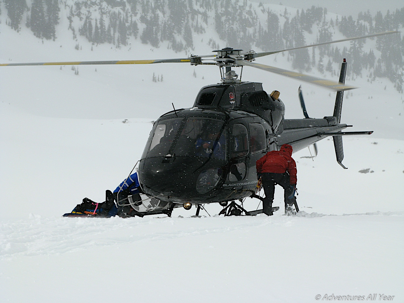
After lunch we again started up: the one last time up. Up into the worsening weather. Part way up I stopped to wait for Bob to catch up: telling the others to go on ahead. 10-20-30-40 minutes later I can finally see him struggling up the hill. He has said that he hasn’t been feeling well these last couple of days and been getting slower each day. It is at this point that I made up my mind that I’m going to make the call for S. A. R. to get him flown out. We finally get up to the others in a blowing, snowy whiteout, where there is some discussion as whether to carry on or not. I said that we are making camp right here and now and going to call out as soon as the tents are up and the stoves are going. I get the call made through to meet the S. A. R in the morning at the Varsity Outdoor Club. V. O. C. hut at the eastern end of Garibaldi Lake and get help.

Day 8: Bookworms Pass down to Sphinx Glacier and out
In the 9 am call to the SAR team in the morning John, their team leader, asks if we heard the chopper. We answer no. He goes on to say that the visibility at the lake is about 6000’ and they have a team at the VOC hut already, and can we get down asap while the chopper can still see to fly. We are about 7800’ giving us 1800’ or so to get below the cloud to meet them and get Bob out. Visibility is nil. We rope up again and start down so painfully slow. Finally!! We can see the lake! Then there are the SAR people! Soon now.
Then things began to happen fast. We unroped, off of the Sphinx Glacier and went as fast as we could down to them. They then took over telling us what was going to happen, where to stop. I was 5th getting up to them and upon arriving they said that I was going out with Bob. Confused, I asked why. Because I was his tent mate, they said. They just presumed I was leaving also, and there was room for one more. I said no, that I was going to finish the trip with the others. So within 5 minutes or so of us meeting the chopper, Bob was on, and away with the SAR members leaving us alone again. We are one less now. The quiet was deafening. The night before I’d said a prayer for Bob and hoped that he would be OK.
The 5 of us left carried on to the VOC hut to have lunch. In a hut, out of the wind. What a treat. This being day 8 and having food for 10 days we had lots left to be eaten as we would be out this night. So we pigged out eating as much as we could. Across Garibaldi Lake and down the trail and we are almost done. Due to there being no snow for the last 2 km we carried our skies to the summer parking lot. Time to call the taxi and ski down the unplowed summer access road to asphalt. Then the usual change of clothes, off to a pub for a burp and a bite and home.
Bob came home from Squamish Hospital on the Monday after. The diagnosis was respiratory pneumonia with symptoms of pulmonary edema. Within a few weeks he’ll be as good as new again.

Leave a comment