Or why this place is not a provincial park is beyond me.
In 2017 we did a backpacking trip that I will never forget. Just 40 km north of Powell River lies an incredible land of massive granite, alpine tarns, glaciers and vertical walls. This place is so stunning that you gotta see it to believe. Yet it is not a provincial park, or any other park, but if you’re willing to go through the logistical puzzle of getting there – it’s waiting to be discovered.
We were initially planning for a water taxi to the head of Toba Inlet and going up from there but the more we learned about the bush in that area the more eager we were to do a float plane to Daniels Lake instead. After much phoning around we were finally successful chartering a ride with Vancity Seaplanes.


After a flawless landing on Daniels Lake we unload gear and see the plane take off again. We’re off into the unknown. We head up the valley at the NE end of Daniels Lake and hike up about 700m vertical to reach a col on the continuous ridge stretching roughly in N->S direction from Toba Inlet towards Powell Lake. It looks all walkable.

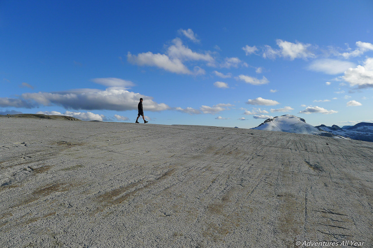
The plan is to set up camp on or close to the ridge from which we can explore surrounding peaks for the next few days. There are MANY places to camp on the ridge and we are actually having a tough time choosing the perfect spot (the tyranny of choice). Eventually an envoy of three scouts comes back with reports of unbelievable expanses of pink granite and a personal tarn for each member of the party. We move slightly up and N from the col and make camp at a place I will refer to as Tarn Heaven. We spend the evening setting up camp and just coming to terms with this unbelievable land of perfectly grippy, clean, bizarre, climb-it-all landscape of giant slabs.

Sep 3, 2017 – Day 2: Reality Check
The following day we set our eyes towards the ridge stretching away N from us and we decide to aim for, gulp, Julian Peak, about 8km away. Scrambling our way along the ridge we soon come to realize that we won’t reach that goal. The terrain, although certainly not more than class 2 or 3 at places, is full on scrambling requiring attention and making our progress slower. The granite, though, is unbelievable – large blocks, super grippy, you can walk up or down slabs tilted at 30 degrees with no problem.

Instead of Julian Peak we summit Chusan Peak and continue a little ways past it and towards Julian Peak. We extensively deliberate an option of dropping down to the bowl to the W of us, skirting the Figure Eight Glacier (I just made up that name) and making a loop out of this outing but we are uncertain whether a particular step regaining the ridge on the other side would go and are reluctant to find out the hard way. So we backtrack to camp the same way we came. Another spectacular sunset that night.
Sep 4, 2017 – Day 3: Everything Chusan
For a day excursion we choose to head along the ridge stretching W from our base camp with the objective to summit Chusan W4 (Tinghai Peak), going over the top of Chusan SW3 (Bremmer Peak) along the way. As previous day, it’s a beautiful class 2-3 scrambling. This granite holds like crazy, allowing us to walk straight up and down every inclined slab like Spiderman.
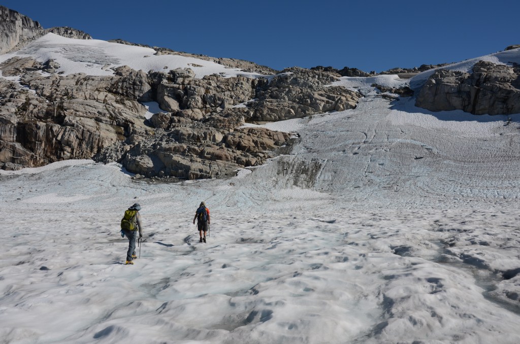
On the summit of Chusan W4 we all take an afternoon nap after which the party splits. Peter and Silke head back towards our camp stopping at the perfect swimming tarn we discovered on the way up. The rest of us are feeling adventurous and we continue W along the ridge past Chusan W4, looking for a spot to drop to the bowl on its N side and returning to camp via a different route. The gamble almost did not pay off as it was quite tricky to find a manageable spot to get off the ridge. This, in general, is applicable to this entire area – once you are on the ridge, that’s it, very few spots to escape from it, the surrounding areas protected by vertical drop offs. Do bring a short 30m rope, for sure, it will expand your range of possibilities. (Crampons and ice axes, although we did have them, were used only minimally and you could get by without them).
Eventually, after about 20 min of going back and forth we finally find a downward sloping slab with a crack in it that we follow to reach a 4 ft wide ramp to the right. This connects us with the smooth slabs in the bowl and we’re home free. At least that’s what we think. However, it turns out to be a very long day where we have to drop way lower than we thought, hop over a glacier outflow creek running high in the hot afternoon sun and still end up at the same crux spot we had contemplated the day before. It was getting late and we decided to cut it short by heading up Round Glacier (a made-up name) to its headwall and scrambling some glacial silt-covered crap until we regained the ridge that took us back to camp.
Sep 5, 2017 – Day 4: Sweat, Smoke and Bears
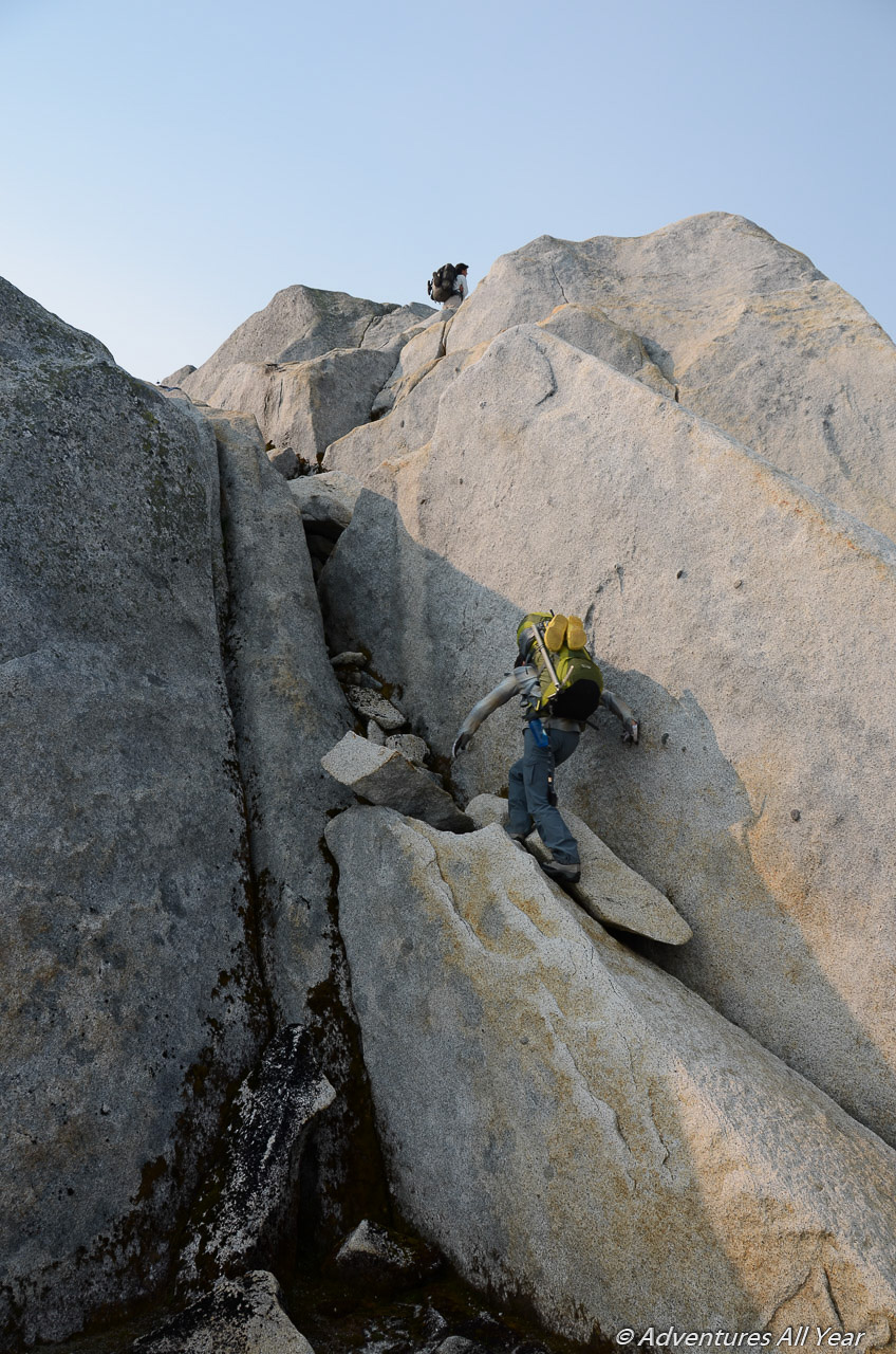
Wildfires smoke rolls in as we pack camp and start heading S, towards Chusan SW5. We plan to stay on the ridge although we know that previous parties were successful traversing across the NW face of Chusan SW5, regaining the ridge on the S side from the summit. We stop often to observe the ridge, assessing whether it goes but the smoke somewhat obstructs our visibility. About one third up there is a spot where you come across a pretty much vertical 7m step with big blocks of broken granite requiring a low 5th class move over a slippy mossy rock. We send Silke first. Without a backpack she climbs it without a problem, even though I am not sure how she’s gonna come back down ;-). After a little bit of scouting and a little wander to the right Magnus discovers a short talus gully that is less technical (but steep and loose) so, one by one, we ascend that and find ourselves walking the ridge towards the true summit. Thus, having successfully resolved the Chusan SW5 problem we rename it a Can-do Peak.
The ridge goes, sometimes the route ahead is not obvious but it does go and we managed to stay on it all the way to the summit of Cando and beyond.
As I mentioned earlier, there are very few escape points from the ridge. So when we reached one (I’ll call it Bear Point) we decided to take the opportunity. It is a veritable bear track, just a faint path disappearing through the trees and down a steep blueberry slope.
Let me talk about bears for a moment here. There is bear shit EVERYWHERE on this ridge. At 2,000m of altitude, bear population uses this ridge system as a promenade to connect between pastures and to get males to females, or so I imagine. Very soon after descending from the ridge at Bear Point we come across a fine specimen of the species, fattening up on the abundance of blueberries in the alpine meadow. After a little standoff the black bear darts off into the bush and we continue traversing towards a small lake N of Lake 4225. Now, I won’t sugarcoat this for you – leaving the ridge was a BAD idea. In hindsight, the ridge would have probably gone. We would have found a camping spot and a little tarn and we wouldn’t have had to deal with 1. Bears, 2. Bugs, 3. Bush. And bush and bugs they were! Holy crap, Magnus’s head looked like an inflated birthday balloon from all the blackfly squads backed up by mosquitos. The only solace came from the fact that when we reached “Sandy” Lake it turned out to be one of the most beautiful alpine lakes I have seen and we even got to camp on a sandy beach!
Sep 6, 2017 – Day 5, Spotted Slab
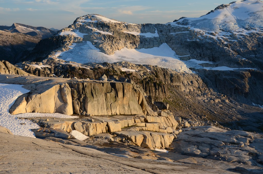
The next morning the smoke is even thicker as we press on. First, regaining the ridge we left the previous night, walking along it for some 2km, skirting around the Shark Fin and continuing south through some crazy Spotted Slab country. The slabs here are pretty much a barrier holding a sizeable glacier from tumbling down into the valley and we enjoy this weird landscape immensely. Watch for fine silt and sand covering the slanted slabs in this area.

We make camp early that evening, in another tarn city (there is definitely no shortage of water here) and looking at the next obstacle ahead – the Slabface (a made-up name). We spend a great deal of the evening looking at the best route over it but also scouting a possible bail-out route as the weather changes to light rain. We are cognizant of the fact that it won’t be easy getting down. Everything is very steep and you really need to choose your route down carefully in order not to be cliffed out. We know of a party from previous year which has descended to the lake below and to the SW of us (Lake 3244) and we also know of a party who successfully navigated the steep slabs high across the NE side of Slabface. We had had a good look at the face from the floatplane on the way in and we all knew that we had little appetite to undertake such a traverse in the rain.
Sep 7, 2017 – Day 6, Vegetation Belays
The weather gods decide for us. We wake up to a gray drizzly morning, slabs getting wet. We continue along the ridge to a low point directly above Lake 3244. Here we pause for a short break and I say my quiet thank-yous and good-byes to the high country around us. I peek W through a notch into Daniels Valley and the steepness and height of the cliffs is dizzying. Soon afterwards we start our descent to Lake 3244 (Refuge Lake). We get cliffed out once but after a little bit of searching we make our way down to the lake, using vegetation belays profusely. We enjoy a lunch break at the lake and at 1pm we press on.
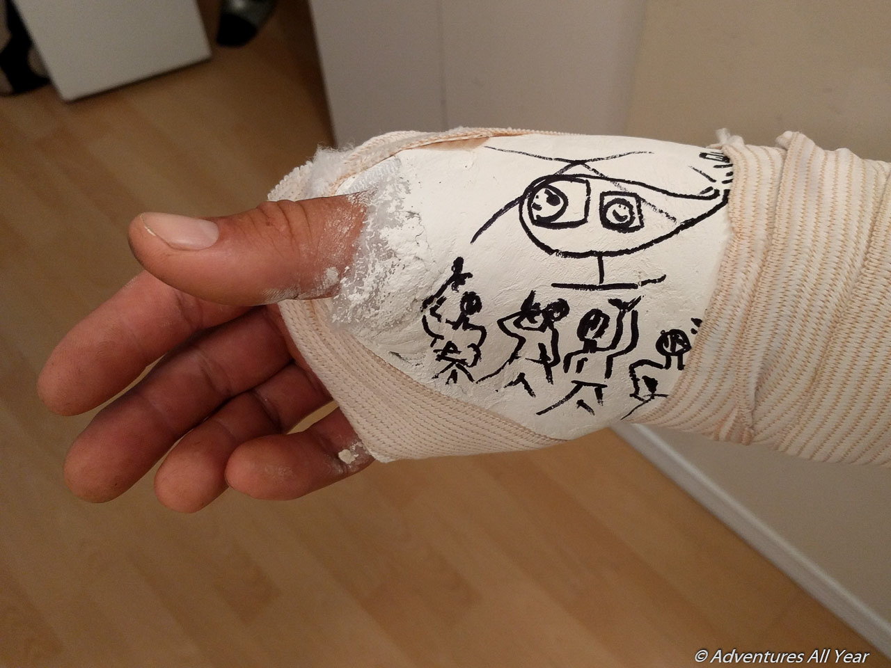
From previous reports we know that the route along the lake shore gets bluffed out so we aim for higher in the forest to bypass the bluffs from above. We still come across some cliffs which we have to detour a bit but it is fairly good going, given the terrain. We are almost congratulating ourselves for reaching the S outlet of the Lake 3244 (Refuge Lake) without an incident when, at about 300m from the intended campsite, Peter M. slips and breaks his arm just above the wrist. I know it’s bad as soon as he lands. Very shortly we go from a walking-along-peacefully into a full-on emergency mode: painkillers, first aid, maneuvering Peter to the camp site, communicating with Powell River SAR (InReach), repacking Peter’s backpack for transport.

We get a confirmation that SAR is readying a helicopter to extract the patient that night. I am grateful for it because the clouds are descending and we’re not sure if a helicopter would be able to fly tomorrow. Things are happening in a fast succession at this point – repacking Peter’s camping gear as we don’t know if they’d extricate only Peter or a companion as well (that would be me). So tent and cooking gear comes out of Peter’s backpack and into mine. Silke and Peter G. are busy chopping down some small trees that are in the way of an already very constricted potential landing spot. Soon we hear a THUMP-THUMP sound up the valley – the chopper arrives roughly within two hours from the time we sent the first InReach message.
It is a small 4-seater, the pilot masterfully landing in an impossibly tight spot with blades only some 2 feet away from tree tops. We get kudos for the splint job and Peter M. is taken out. Soon after they leave it starts raining in earnest. We eat dinner in darkness and hunker down for a miserable wet night, the tents pitched right next to a big pile of bear shit.
Sep 8, 2017 – Day 7, Mother of a Bushwack
Today we experience a five hour holy bejesus mother of a bushwack. But at the time we wake up we don’t know this yet. We don’t yet know what’s ahead, whether we’d come to an impasse or how bad the bush is. It is bad. There are places where we don’t even touch the ground, just crawling on thick tangle of alder branches feet above the ground. There are moments when I find myself holding on to devils’ club for support. The slide paths are the worst and we try to stay away from them as they are complete coastal hell, too thick with young snappy bush. We try to keep to an old growth as it is much more tolerable.
After 5.5hrs of this suck we emerge on a spanking new road recently put in by a logging / mining / hydro company. It is so wide and solid that an army of tanks can drive on it in a festive procession. God bless it because it takes us, the easy way, to the N end of Powell Lake – some 10 km down the road. We arrive at a deserted logging camp at the lake, set up tents directly on the wooden float deck, and are lulled to sleep by gentle rocking of the waves.

Sep 9, 2017 – Day 8, As if It Didn’t Happen
A blustery morning. Many whitecaps on the lake and wind blowing hard. Full-on rain. We’re wondering whether our boat ride will come to pick us up, given the conditions. Around 11am we see two speedboats slicing through the waves. It is Justin and his helper, paying good to his promise to get us out as agreed. It is a cold wet ride out on a 40km lake but in a little over an hour we go from a complete remoteness to the comforts of the Powell River Marina. At 6pm, after what was a blur of car and ferry rides, and a little bit dazed we are back in Horseshoe Bay with crowds of ferry passengers whirling past us.
Thanks to Hana who was not on the trip but was a vital communication link instrumental in getting Peter M. out promptly. Thanks to Magnus, Silke and Peter G. for being there, I would go to the end of the world with you.

Wow!