I like, ehm, logistically involved trips. Those which involve multiple means of transportation and complicated arrangements from water taxis (at a minimum) to scheduled float plane pick ups in order to just get to the starting point. The trip to Widgeon Lake was somewhere in the “moderate-low” range of that scale but offered great rewards for that little bit of extra effort.
To get to Widgeon Lake trail you first need to get across Grant Narrows (Pitt River) and weave your way through a system of slow-flowing channels in Widgeon Creek marsh. For that you need either a canoe or a kayak. I personally prefer kayak because they are so sleek and fast and make you look really good but for $55/day you can easily rent a canoe from a place directly at Grant Narrows (8am-8pm in summer months, no reservations, first come-first served system, cash only) and launch yourself, in your boat, towards Widgeon Creek mouth, directly across from the Grant Narrows parking lot.

The Widgeon Creek marsh is tidal so the water level varies depending on the time of the day but is never fast flowing. The marsh itself is a beautiful bird sanctuary with interesting grasses and shrubs along its banks but only a handful of places to pull over and enjoy a picnic. However, a great place to pull ashore and a natural destination for day trippers is Widgeon Creek provincial campground at the further reach of Widgeon Creek. Finding it is not difficult as there is a sign pointing left at the only place where the water channel splits. The total distance from Grant Narrows launching spot to the campsite is 4.5 km and comfortably doable in under an hour of paddling. Crossing the Grant Narrows is the most exciting part as there is usually a lot of powered watercraft traffic. They technically do have the right-of-way but the operators, in most cases, are nice enough to slow down to a snail pace and let you pass.
After the initial paddle leg of the journey you reach the Widgeon Creek campsite. From here, look for a trail that starts at the outhouses and leads north. Again, it is very easy to find and even easier to follow as it is, in fact an old roadbed. Even if you don’t feel like hauling yourself all the way up to Widgeon Lake (an elevation gain of 750 m), a shorter 3 km trip to Lower Widgeon Falls is worth the walk over a good, mostly flat trail. You’ll make it even in sandals. Don’t forget to look out for salmon berries, tayberries and thimble berries in the bushes lining the trail.
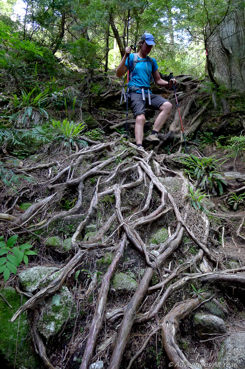
After 2.5 km, the easy trail forks and there is a BC Parks sign pointing left to Widgeon Lake (6.4 km from that point on). The trail gets bushier and with larger rocks under your feet but still easy to follow. You’ll cross a dilapidated road bridge over a major creek, impassable for any vehicle but still plenty substantial for foot traffic. Higher up you will cross Widgeon Creek one last time, on an old wooden bridge with safety railings on both sides. From here on, the trail starts picking up elevation in earnest and this is also where you earn your swim. The trail, still easy to follow if you pay attention to flagging has fascinating root formations and a few steep steps but if you’ve done other similar trails in BC such as Mt. Bishop or Coliseum Mtn. nothing on this one will be a surprise to you.
In no time you’re top out at a bluff overlooking your priced destination – Widgeon Lake. This bluff is a great flat camping spot to pitch your tent, however, it does not have access to (any) water as you are perched about 50m above the lake. To actually reach the lakeshore, continue left from the lookout following a flagged trail and this will lead you down to the water level.
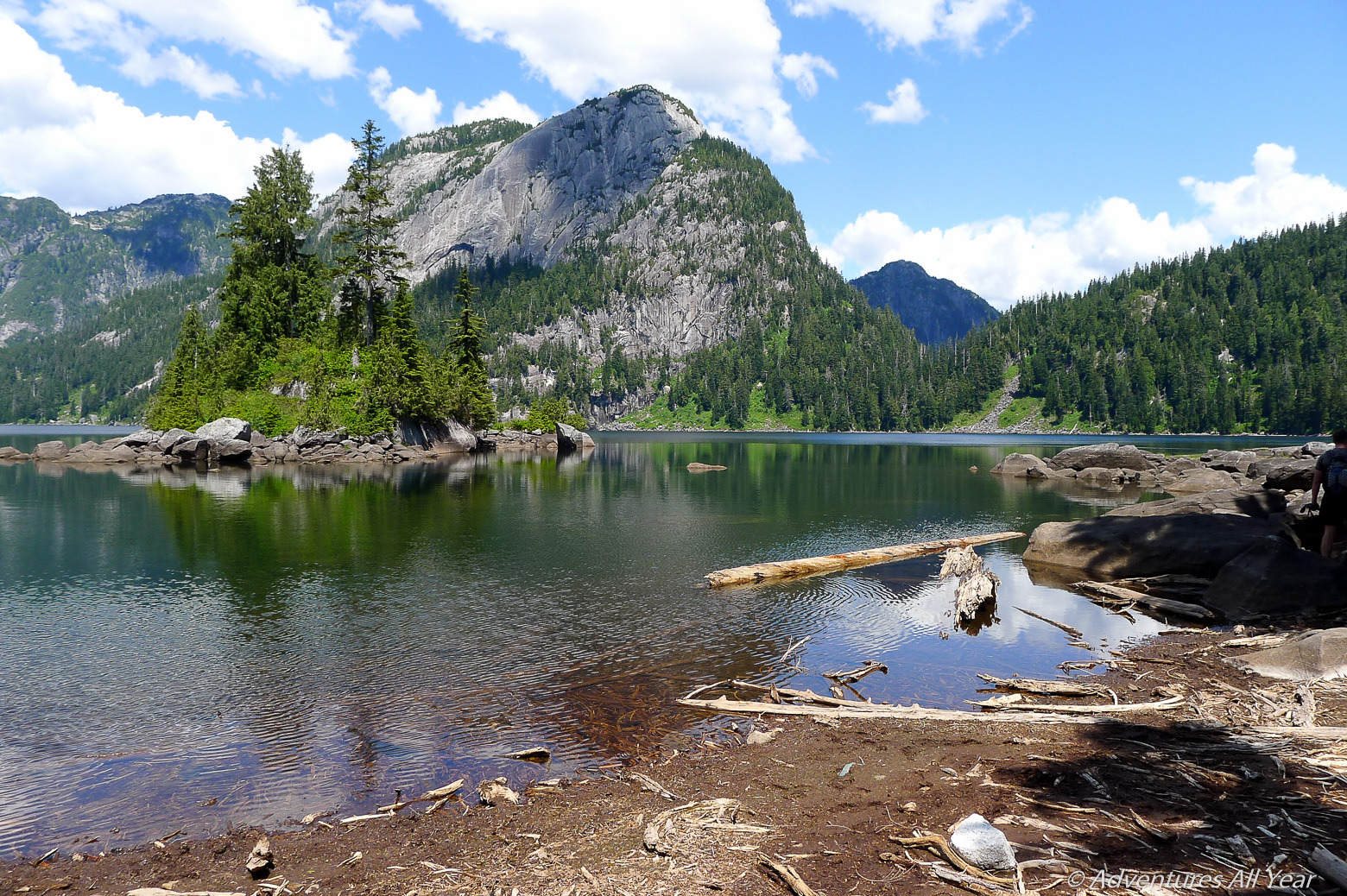
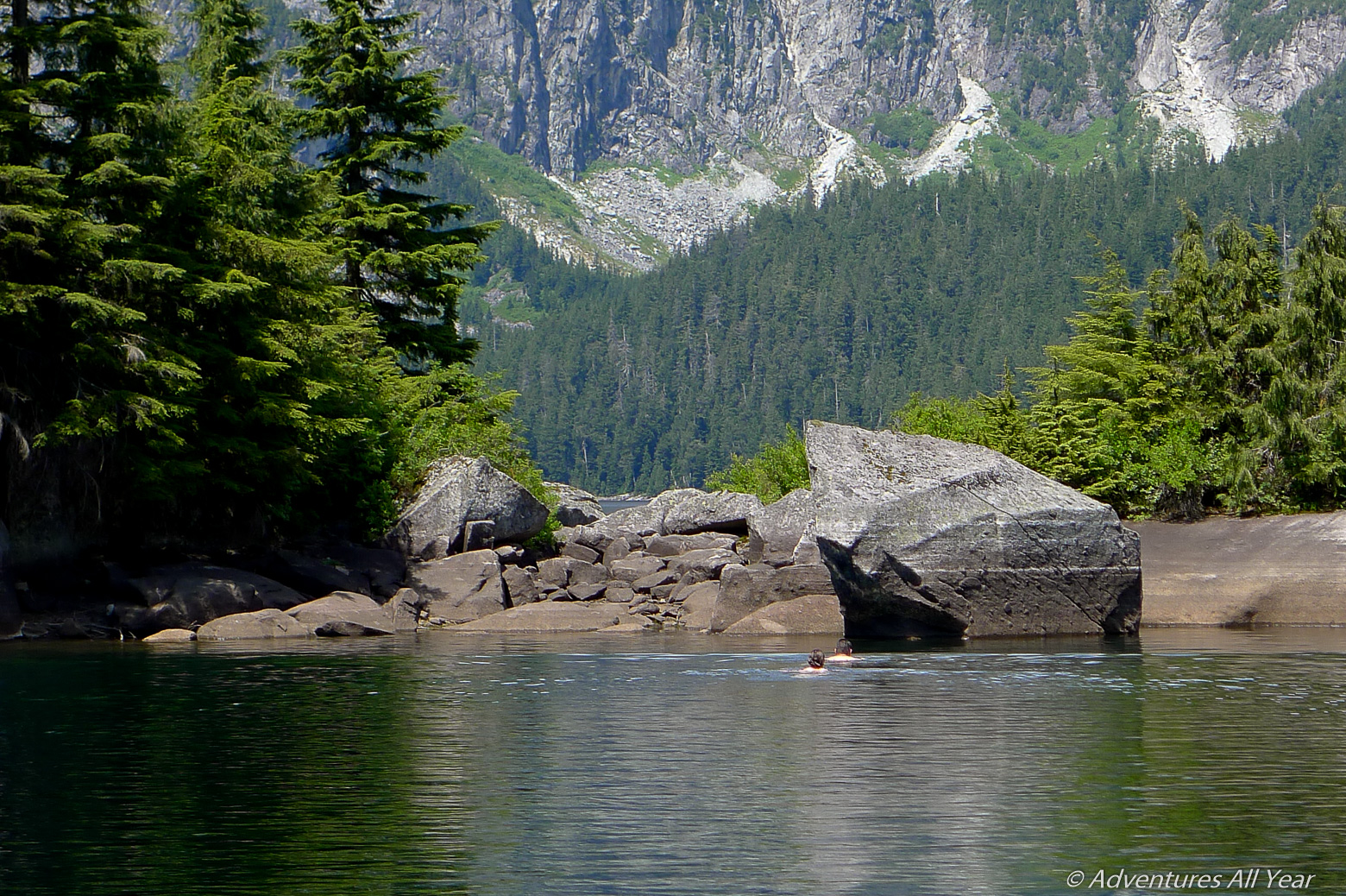
From the rocks on the shore you can hop into the water and swim to your heart’s content. I’ll let you on a little secret here: once you get to the lake, hop on rocks following the shoreline on your right. You’ll get a fantastic monolithic boulder protruding into the lake, laying on its side, gently slanting into the water, a perfect spot for entering the water or lounging on a warm rock. In addition, there is a small rocky island about 40m offshore and within easy reach, with its own resident fir tree and more great jumping rocks. The lake is in a beautiful setting, surrounded by steep mountains of solid granite on all sides. It is actually impossible to walk along the lake shore to the west end so enjoy the scenery from the here and send little thanks to be able to enjoy it so up close.
So for the naysayers who had warned us – yes, you can get down to the lake from the lookout bluff. No, the trail up to the lake is not a Road from Hell as described on some hiking forum. And yes, the destination is worth the 1-hr paddle across the marsh and the 4-hr hike that follows. Happy summer days.

Hello! Thanks for this great post. I’ve always wanted to do a canoe – hike – camp adventure and this looks like such the perfect trip! I’m curious about leaving your canoe/kayak at the creek campground while you hike & camp overnight at the lake however. Is it generally safe to keep your boat at the creek with nobody watching?
Hello, we were in a rented canoe so nothing that would attract much interest but I think we still hauled the canoe up the bank and chained it to a tree with a looong cable lock. Having said that – most people just left their kayaks/canoes unsecured. There was always someone at the beach (a campsite is nearby) and there were many day trippers and everyone seemed just kind of chill. Hope you have a great trip – the Widgeon Lake was one of my favourite backcountry swims ever!
Thanks so much for your reply, Alina! I’m looking forward to it 🙂